Risk rising with aging dams
Climate change and dam safety will drive decisions on the fate of many NY dams
Summary: New York State has nearly 6,000 dams, with an average age that is decades older than dams in the rest of the U.S. Many of these structures have surpassed their design life, making rehabilitation or removal likely in the future. In the Mohawk Watershed, there are over 400 dams, with an average age even older than those statewide. The 2009 New York State dam safety regulations marked an important step in addressing the risks associated with aging dams, but many dams are not compliant. As many of these structures continue to deteriorate, they face three possible outcomes: rehabilitation and maintenance, removal, or neglect. A significant subset of our dams are impaired and beyond their design life, and they pose risks to downstream communities. With rising annual precipitation and more frequent extreme weather events in the Watershed, these high-risk dams should be prioritized in climate adaptation and flood resilience planning.
Dams have been a central feature of watershed hydrology in the Northeast and New York State for over two centuries. The Erie Canal and numerous mill dams were integral to driving commerce in the nineteenth century, and since then they have been woven into the fabric of every watershed in the State. Many dams were constructed during the Progressive Era (late nineteenth and early twentieth century), with a significant build-out culminating between 1910 and 1930. The Golden Age of dams followed, mainly between about 1950 and 1979, and after 1990 almost no dams have been built [1]. Dams in NYS served various purposes, including transportation, recreation, water supply, hydroelectric power, flood control, and navigation. However, increased precipitation and extreme rainfall events are now challenging the capacity of this aging infrastructure, raising concerns about their resilience and safety.
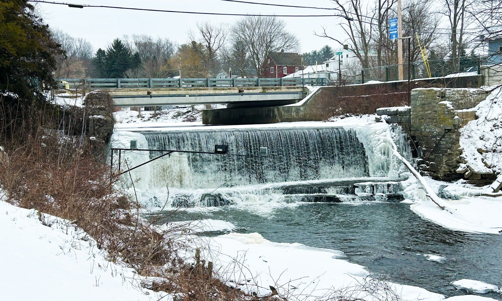
The Harrower Lower Dam on the North Chuctanunda Creek in Hagaman NY was built in 1898 as a hydroelectric scheme. Over time, the reservoir behind the dam has filled with sediment, and the DEC reports that this intermediate hazard dam is “unsound” and it has no Emergency Action Plan on file and no inundation map of record (here). This dam, like many others in the Mohawk Watershed, is now a permanent fixture and a symbol in the town, thus removal is unlikely. However, addressing its deficiencies will eventually require significant investment. It is privately owned (photo: JA Smith, 1/2025).
There are nearly 6000 dams listed in the NYS dam database [1]. It is not quite clear how many dams there are in the Mohawk Watershed; the NYSDEC database lists 402, but there are others, mostly abandoned, not on that list. This constellation of dams includes over 30 high-hazard dams and over 50 intermediate-hazard dams. This hazard rating is based on the consequences of failure rather than on dam condition. We know there are high-hazard dams that are also in disrepair, and thus these are the dams that pose considerable risk to communities. On average, however, high-hazard dams also provide the greatest benefit to society.
For the most part, flood mitigation efforts and removal have been focussed on those dams that are high-hazard and intermediate-hazard (Class C and Class B), because failure of these dams can have economic consequences and may result in loss of life [2]. But this focus tends to ignore the major impact that thousands of low-hazard dams have on blocking ecological connectivity, trapping sediment, and exacerbating flooding.
We rely on the American Society of Engineers (ASCE) to grade our infrastructure [3]. The recent ASCE (NY council) report card on NY infrastructure has some sobering news about the dam challenge in NY State. In the 2022 report, they note that NY dams are significantly older than those elsewhere in the US and that many have exceeded their original design life of 50-75 years. The average age of NY dams is 29 years older than elsewhere in the US [3]. An issue ASCE highlights is that “state regulators still lack the capacity to keep up with the permits, reports and questions that dam owners need reviewed in a timely manner” [3]. One thing that is needed is better funding for regulators to inspect, monitor, and regulate dams. “Many states, such as South Carolina have as many as 20 staff to oversee the dam safety program, New York has approximately 8 full time dam safety officials for approximately the same number of dams” [3].
We definitely need to worry about dam failure in the Watershed. During flooding from Hurricane Irene (August 2011) and then Tropical storm Lee (Sept 2011), ten dams in the Watershed either breached or had their Emergency Action Plan (EAP) activated, and thus there were serious issues with flooding, sediment release, impairment of local infrastructure, and public safety. The EAP is the plan on file for the actions to be taken if the dam is threatened, breached, or has failed, and both high- and intermediate-hazard dams are required to have them on file with the NYS DEC [4].
Old dams, and lots of them. Let’s look at the numbers. The NYS DEC database for dams in NY State includes nearly 6000 dams [1]. In that database 20% do not list a date built, but the other 80% of the listed dams includes 4761 dams that were built from 1699 to 2022 [1]. The first phase of dam building was associated with mills in the early to mid 1800’s. Most of those dams have been replaced or abandoned, although ~8% percent of the DEC-listed dams in the State that are dated were built prior to 1900. In this group of old dams nearly 60% were built between 1870 and 1900. But building seems to have continued to c. 1930, and collectively these dams are the result of modernization of the Progressive era.
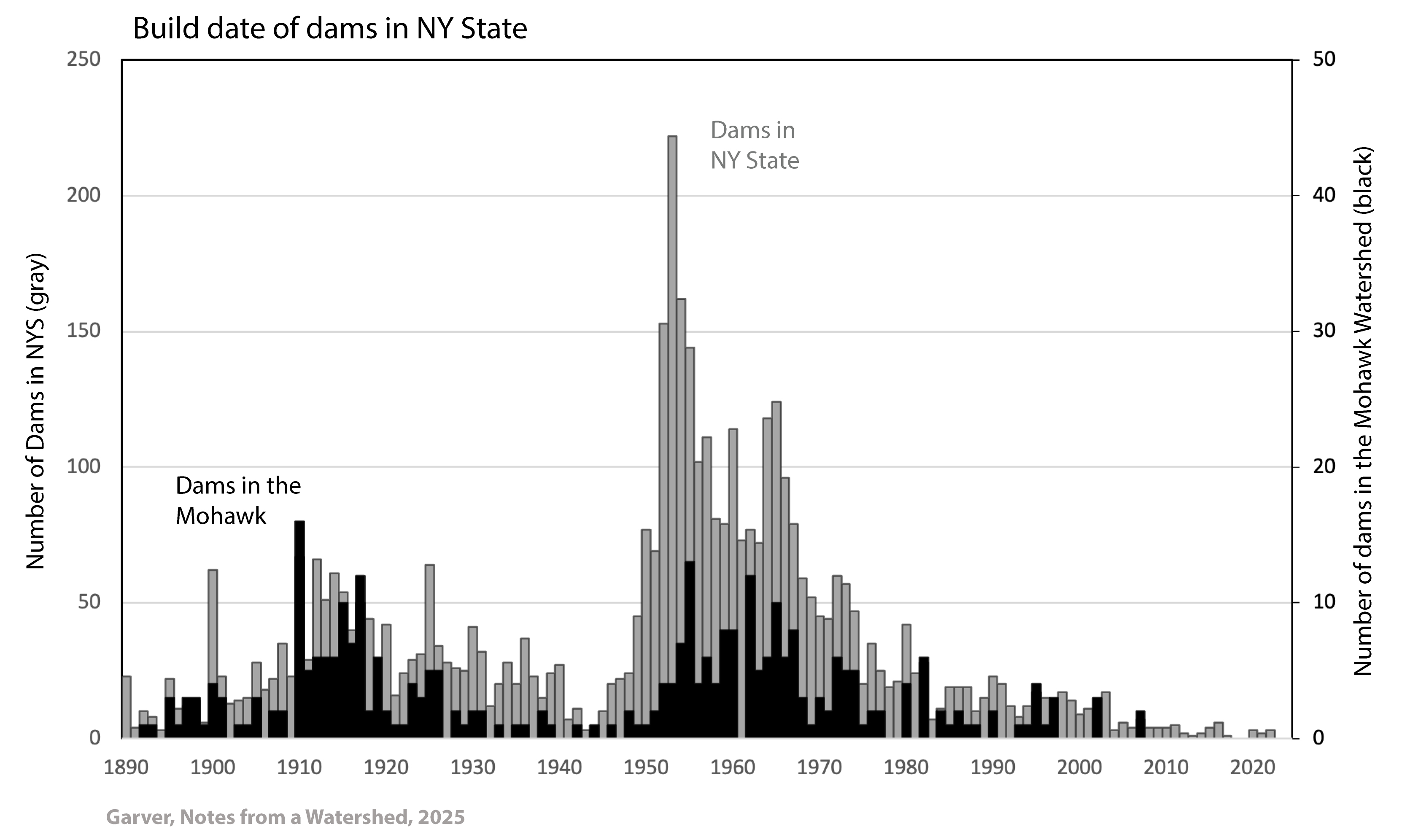
Age distribution of dams in NY State (gray), and all dams in the Mohawk Watershed (black, right axis) [1].
About 78% of current NYS dams were built between 1910 and 1980, and there are two primary dam-building periods in NYS in the last 130 years that emerge from the current database (many dams from the 19th century mill dam build-out are no longer with us). The first major dam-building period was between c. 1910 and 1930 (18%), and the second was between c. 1950 and 1979. The latter period, the Golden Age, accounts for over 50% of the currently listed dams in the State. Very few dams have been constructed in the last few decades.
There are 401 dams listed in the Mohawk Watershed, and of those dams 84% have a known year in which the dam was built [5]. These dated dams were built from 1813 to 2007, and of this group, 76% were built between 1910 and 1980, a number similar to the rest of the State. However, proportionally the number of dams that were built in the Mohawk Watershed between 1910 and 1930 is nearly double the number in the State as a whole.
A point here is that dams in NY and the Mohawk Watershed are old. In the US, the average build date for all dams is 1957 [6]. In NY State the date is 1942, and in the Mohawk Watershed is just under 1940 [5]. The Mohawk Watershed has a significant number of dams that are about 100 years old - the “Century Club” - more so than the rest of the State. The number of dams in the Century Club is troubling because most are in disrepair and not doing the job they were built for. On top of this average annual precipitation has increased significantly [18,19,20,21,27]. Thus this group has a number of candidates that are prime targets for dam removal for public safety.
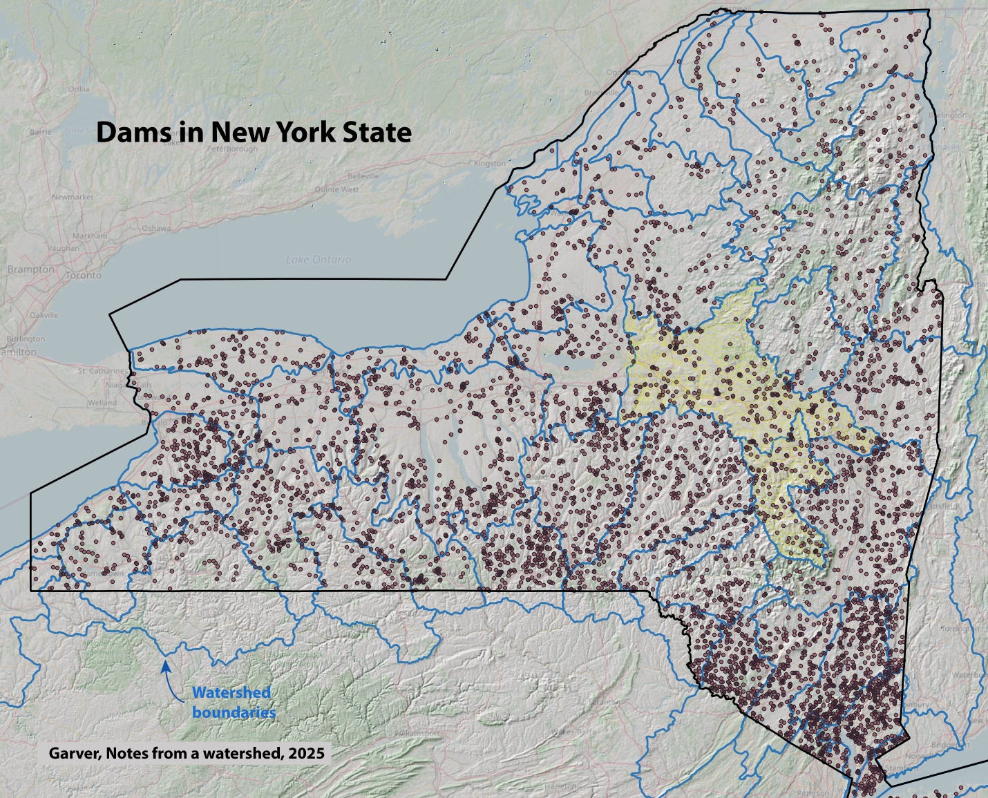
Map showing the constellation of NYS DEC listed dams (excluding NYC and Long Island) and the outline of the Mohawk Watershed [data source see 12].
If we look at those century-old dams in the Mohawk Watershed, we see that that were built for a variety of reasons, including recreation (~25%), water supply (23%), hydroelectric power (18%), flood control (11%), navigation (9%), and other reasons (22%) [7]. This group of dams includes many big public works projects including those for the third phase of the Erie Canal, which regulated the Mohawk and its feeder systems, the Gilboa Dam that impounds a water supply for NYC (below), and many smaller dams.
In the US, the Big Dam Era extended from the 1930’s to the 1970’s, and some of the most significant projects were out west [8,9]. This era was supported by government-backed public works programs and advances in dam engineering, and they were driven by water management needs for agriculture and urban development. But statistics using the National Inventory of Dams indicate that the Golden Age of dam building was between 1950 and 1979, when three to six dams were completed per day [10].
Big dams in NY are smaller than the big dams out west. There are about 60 dams in NY State that are higher than 75 ft (<1%), and of those dams 51% were built in the Progressive era (1880 to 1930), and 31% were built in the Big Dam era (1930 to 1970, but in NY that date range is from about 1950 to 1979). Most of these dams are for water supply (47%, primary or secondary), hydroelectric (35%), and flood control (22%) [7]. The youngest big dams in NY State, which are over 100 feet high, are the two dams that support the Blenheim-Gilboa pump storage project on the Schoharie Creek (located just downstream from the Gilboa Dam that impounds part of the NYC water supply). These two dams were licensed in 1969 and completed in 1973 as an on-demand hydroelectric battery for downstate daytime electrical needs. The Blenheim-Gilboa project was built after years of contentious debate about siting a similar project by Con Ed on Storm King Mountain on the lower Hudson River.
In the Golden Age of dam construction in the Mohawk Watershed, the purpose of dams changed: over half of the dams were built for recreational purposes. Since the decline of dam-building following enactment of environmental regulations, few dams have been built in NY or the Mohawk Watershed. Very few dams have been removed either [11].
The 2009 New York State dam safety regulations marked an important turning point in the State's efforts to address risks from aging dam infrastructure [4]. These regulations placed greater responsibility on dam owners, particularly those of high- and intermediate-hazard dams (Class C, B), requiring periodic safety inspections, engineering assessments, maintenance plans, and Emergency Action Plans (EAPs) [2,4].
For Class C high-hazard dams, the EAP has a number of requirements, including the activation protocol by which owners notify emergency management officials if flooding is expected or if dam failure is imminent or has occurred. The EAP also includes inundation maps tailored to downstream conditions and potential failure consequences [12]. These maps model two scenarios: a "sunny day" break under normal conditions and a "rainy-day plus dam break" approximating a 100-year flood. A central aspect of these regulations is the increased accountability and responsibility placed on dam owners.
Why is this discussion of dam age and safety regulations important? Dams in NY are aging, with those in the Mohawk Watershed being even older than in the State as a whole. In addition, precipitation is increasing, as is discharge in our rivers. Thus many old dams, fit or not, were not built for the current climate. As these structures continue to age, old dams have three possible trajectories: rehabilitation and maintenance, removal, or neglect. All three trajectories are likely, but the proportion of dams that are removed or neglected can be steered by policy decisions.
Functional dams with direct economic and societal value will continue to be maintained. Many dam discussions fail to differentiate between functional, societally-relevant structures and a significant subset of aging dams that are beyond their design life, are commonly impaired, and pose risks to downstream communities. These latter high-risk dams should be prioritized, especially in climate adaptation plans.
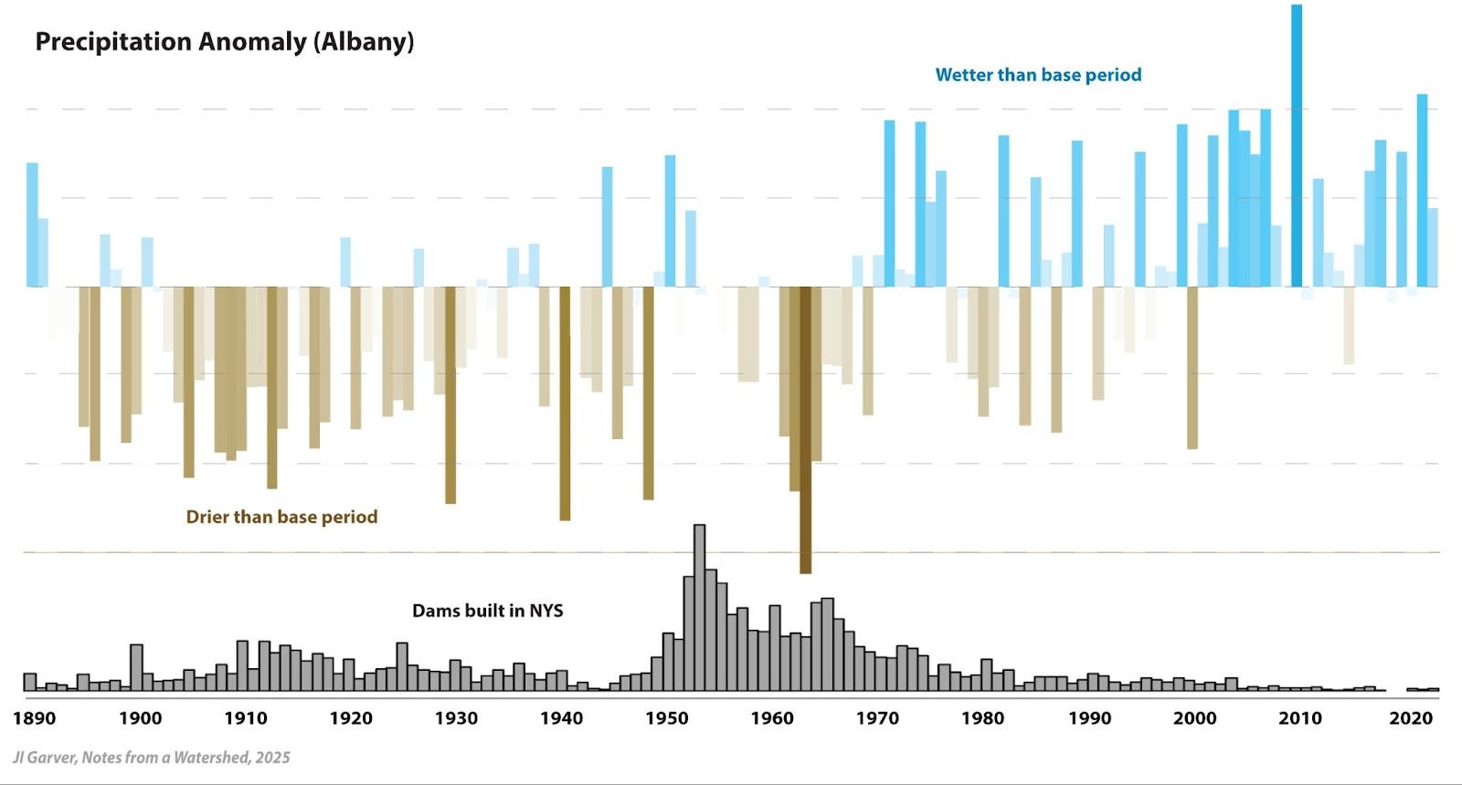
Annual precipitation anomalies at Albany compared to build date of dams in NY State. For anomaly calculations see [27]. Since the years in which almost all dams in NY were constructed, the climate has changed, and higher streamflows challenge many dams.
Dam maintenance, especially for older dams, can be expensive. The largest dam in the Mohawk Watershed is the 185 foot high Gilboa Dam, which is a high-hazard dam built in 1927 [1]. This dam supports the Schoharie Reservoir and Shandaken Tunnel, which is part of the drinking water supply for NYC, and is owned by the NYC Department of Environmental Protection (NYC DEP) [2,13]. This is the only major project in the Watershed that results in significant out-of-basin transfer of water. Some call this human-induced “stream piracy” and the effect of that water loss is most pronounced in the summer months because the loss of water in Schoharie Creek affects the downstream fishery [13].
A major $400 million rehabilitation effort has just been completed on the Gilboa Dam and associated infrastructure on the Schoharie Creek. Dam deficiencies were identified in 2005 in the spillway and earthen embankment of the Gilboa Dam and the NYCDEP issued a declaration of emergency that initiated a long and expensive rehabilitation process [14]. In a 2005 public meeting with local residents, Emily Lloyd, then commissioner of the NYC DEP, was quoted by the NYT as saying: “We don’t expect to have a failure of the dam… [but] We do have some concerns that we want to share with you…” [26]. Statements like this are sure to raise both eyebrows and hackles of those living in downstream communities. Subsequent meetings heightened awareness of dam safety in Schoharie, Middleburgh, and other villages and towns along the Schoharie Valley corridor.
The dam was in poor condition, and storms seemed to be getting bigger. A 2008 scoping of the project noted that “It was discovered that over the life of the dam, several floods have slightly exceeded the dam’s original spillway design flow (SDF) of 52,700 cfs.” [14] (cfs is cubic feet per second). Engineering analysis also revealed that the dam sat on sedimentary rocks that had weak planes that may allow sliding of the dam downstream in the event of a major flood. Prior to this discovery of impairment, the flood of record was the devastating January 1996 thaw/rain where the dam passed an estimated discharge of 70,800 cfs, which was slightly less than the calculated 100-year storm of 72,550 cfs [a14]. In the following years the rehabilitation proceeded, and part of that included anchoring the dam to the bedrock.
The dam safety regulations in 2009 required, among other things, sunny-day and flood-condition inundation maps for failure of the Gilboa Dam, which at the time were sobering, to say the least. A collapse could send water down the valley at between 250,000 and 400,000 cfs, which would be apocalyptic for communities in the Schoharie Valley where flows of 50,000-80,000 cfs are considered major. In an article entitled “A plan for the unthinkable deluge,” Brian Fitzgerald, writer for the Albany Times Union, tried to get a sense for the magnitude of such a disaster: “Government officials have a pretty good idea and it is frightening.” [15].
In 2011, Hurricane Irene tested this rehabilitation, which was still underway when the storm hit. On Sunday 28 August 2011 the Schoharie Creek crested at the Gilboa Dam with an estimated flow of ~120,000 cfs, the largest flow rate ever recorded, by far [16]. The storm caused $12.4 million in damage to the dam, and it tested safety procedures in a way that had been previously unimaginable [17].
If flooding and dam impairment from Hurricane Irene was a “black swan” event, we can just keep our fingers crossed and move on. But if it is the shape of extreme events to come, we need to reconsider the design standards of our older dams. The recent flood events that have stressed the Gilboa Dam are part of the clear increase in annual precipitation and extreme events in the watershed [18,19,20, and 21]. The increase in extreme precipitation events and annual precipitation means that not only do we need to rehabilitate older dams, but also that they need to be better and bigger than before if we want them to last. A 100-year old dam was not built for today’s climate.
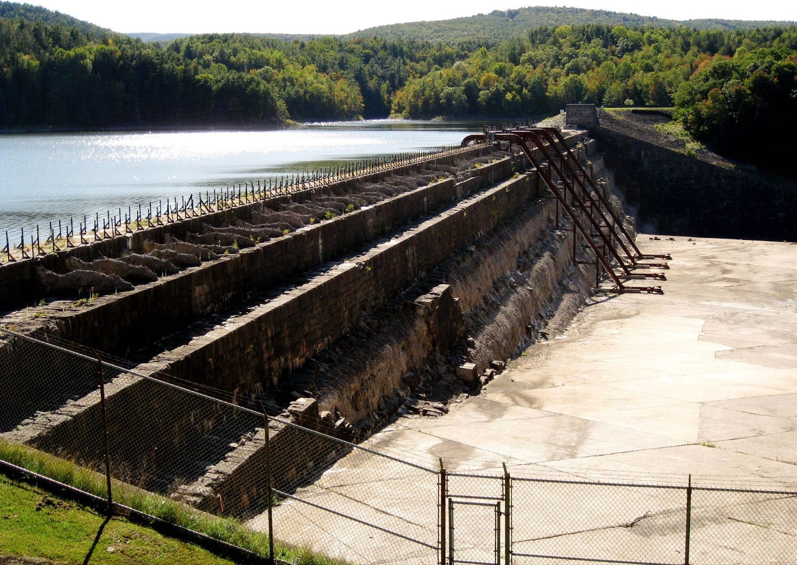
The 185’ high Gilboa Dam on the upper Schoharie Creek is part of the NYC water supply that was completed in 1926. In 2005 it was found to be deficient and unsound, and this initiated a long and expensive rehabilitation that is now complete. This photo was taken in 2009 at the onset of rehabilitation that was at the center of a $400 m project [2]. After the urging of Dam Concerned Citizens, siphons were installed to facilitate drawdown because the low-level outlet was impaired (photo: JI Garver, 9/2009).
Another example of the challenge of the cost of aging dams is the Colonie Dam in Clifton Park, built in 1953 during the Golden Age of municipal water infrastructure [22]. This 57-foot-high dam impounds the Stony Creek Reservoir, which served as a drinking water source for the Latham Water District (LWD) until 2004, when the District switched to the Mohawk River, likely due to the reservoir’s high organic carbon levels complicating treatment processes [22]. In 2021, LWD considered selling the dam because the reservoir was not being used as a raw water source, but the town faced local opposition (and likely a lack of high bids), so the dam remains part of the LWD portfolio. As a Class C high-hazard dam, it remains under the scrutiny of the NYS DEC. In 2021, the LWD estimated the dam’s annual costs at $250,000, punctuated by one-time costly events like the 2001 failure that cost the district $1 million [22]. Today it is maintained as an emergency backup water supply for the Latham Water District.
Both maintaining and removing old dams are costly endeavors, but societal and ecological costs should be considered in the evaluation process. Dam removal is complex, and while analysis of the dam-removal databases (American Rivers, USGS, National Inventory of Dams) shows little correlation between removals and dam age [10], this nationwide trend may not hold in New York, where the dam inventory is older than the national average.
Dams can be expensive and complicated to remove. Amsterdam NY has a special elevated hazard from seven dams that have been identified by the community as high risk [23,24]. The Harrower Pond dam is a high hazard (Class C) deadbeat dam that is the only dam in the Watershed that is out of compliance, primarily because there is no Emergency Action Plan on file and the dam is unsafe and unmaintained. There is a long and complicated story of ownership that is explored in a past post entitled “Deadbeat dam: Harrower Pond dam” (here) [24]. Following flooding from Irene and Lee in 2011, the NY Rising plan submitted to the Governor included a $1.5 m project that would include the assessment of the Harrower Pond dam for the suitability of rehabilitation and then integration of this dam and small reservoir into green space along the creek. This slated money wasn’t for removal, just study of removal and development of a green space.
The cost of inaction will be borne by communities at risk. Remember that here we are focussed on those dams that have outlived their useful life. Many are abandoned Class B and A (intermediate- and low-hazard dams) that disrupt stream connectivity and trap sediment. Climate change is resulting in bigger storms and extreme events [21], and these storms have unleashed a torrent of sediment in the Watershed [25]. Future removals that are already on the drawing board will focus on removing these dams to mitigate flooding and regrade streams that are choked with sediment from the new climate normal.
The derelict Glenridge Sanitorium Collecting Dam on the Indian Kill in Glenville, NY, was originally built in 1930 as a water supply system for the then newly built Schenectady County Hospital for tuberculosis. The six-foot high dam is a low-hazard dam last inspected in 1972 [1]. The entire reservoir behind the dam is filled with about 850,000 cubic feet of sediment. It is unlikely that any action will be taken here. It is owned by the Town of Glenville (JI Garver, 3/2022).
We are at an inflection point with a large subset of dams in the Watershed. Many owners will likely give up on under-performing or non-performing dams due to increasing maintenance costs and liability. Local communities are evaluating removal to reconnect floodplains and facilitate flood mitigation efforts. It is clear, however, that many problematic dams will not be addressed and local communities, both human and aquatic, will continue to bear the brunt of abandonment. Increased annual precipitation and an increase in the number of extreme events in the Watershed means that our aging dams may not be up for the challenge that lies ahead. So it is time to take a hard look at our dam problem.
Further reading and notes
[01] All dams in New York State and in the Mohawk are from NYS DEC database (updated in 2024). Data for dams in NY State are available from the NYS GIS database (here). (1/25)
[02] Dinapoli, TP. 2018. Dam Infrastructure: Understanding and managing the risks. NY State Office of the Comptroller. June 2018.
[03] American Society of Engineers (ASCE). The last NY report card was released in 2022. American Society of Civil Engineers, NY State Council. 2022. Report Card for New York Infrastructure. The section on dams was authored by Ken Avery, Claire Brady, Lisa Dolphin, James Guistina, and Greg Johnson (here).
[04] NY DEC State dam safety information for owners is here.
[05] This includes the dated dams on the DEC database, which is a total of 4760 total dams. For the Mohawk Watershed this includes the dated dams in the database, which has a total of 402 entries, 336 which are dated (NYS DEC data base from GIS).
[06] US Army Corps of Engineers, National Inventory of Dams: Dams of the nation (website here).
[07] The total number of dams in different use categories does not add to 100 because some dams have multiple uses.
[08] Billington, D.P., Jackson, D.C. and Melosi, M.V., 2005. The history of large federal dams: Planning, design and construction. Government Printing Office.
[09] Lee, Gabriel. 2023. “Overview: The Big Dam Era.” Energy History Online. Yale University. 2023. https://energyhistory.yale.edu/the-big-dam-era/
[10] Grabowski, Z.J., Chang, H. and Granek, E.F., 2018. Fracturing dams, fractured data: Empirical trends and characteristics of existing and removed dams in the United States. River Research and Applications, 34(6), pp.526-537.
[11] The American Rivers database of dam removals in the US is here. They note “American Rivers’ Dam Removal Database includes all dam removals in the United States (of which we have been made aware) in which a significant portion of the dam has been removed for the full height of the dam, such that ecological function, natural river flow and fish passage can be restored at the site. This database is revised and updated annually with information provided by contributors across the country. The database may be used by anyone provided that citation is given to American Rivers and the DOI link is included” Last update: November 2024.
[12] Topography from the Mapzen global terrain model. HUC-8 watershed boundaries from USGS at the Cornell University Geospatial Information Repository (CUGIR). Dam database from NYS DEC GIS, and removals from American Rivers.
[13] Bartholomew, H, and Quinn, MS, 2009. The Gilboa Dam and Schoharie Reservoir. In Cockburn, J.M.H. and Garver, J.I., Proceedings from the 2009 Mohawk Watershed Symposium, v. 1, p. 3-7.
[14] NYC Department of Environmental Protection, 2008. Environmental Assessment (of the Gilboa Dam) - Attachment 1: Project description, July 2008.
[15] Fitzgerald, B., 2012. “A plan for the unthinkable deluge: Gilboa Dam called safe, but report details a worst-case scenario” Albany Times Union. 8 January 2012
[16] Much has been written about the Gilboa Dam in Hurricane Irene. Key items from this passage age from the after action “incident reports” by the NYS DEP. See “Supplement for DEC required EAP post-incident report from Gilboa EAP Activation, 12:15 PM, 8/28/2011 (no author attributed, but by the NYC DEP).
[17] Munger, E., Jr. 2012. “Gilboa Dam upgrade project reaches milestone” Daily Gazette, 7 January 2012.
[18] Cockburn, J.M. and Garver, J.I., 2015. Abrupt change in runoff on the north slope of the Catskill Mountains, NY, USA: above average discharge in the last two decades. Journal of Hydrology: Regional Studies, 3, pp.199-210. (here)
[19] Garver, J.I., 2021. Extreme Rainfall in the Northeast: It's raining a lot and our wastewater system is bursting at the seams. The resulting sewage overflows are impairing our waterways. Notes from a Watershed at Mohawk.substack.com (Here)
[20] Garver, JI, 2023. Increased summer rainfall in the Mohawk Watershed; Water quality, flooding, and ecosystems are affected by more warm-month rain in the Mohawk Watershed. Notes from a Watershed, Mohawk.substack.com
[21] Plummer, I, and Garver, JI. 2023. Changes in temperature and precipitation patterns in the Mohawk Watershed: implications for flooding, water quality, and ecosystem health. In Proceedings of the 2023 Mohawk Watershed Symposium, v. 13, p. 54-58.
[22] Garver, JI, 2021. Sale of the Stony Creek Reservoir: Liquidation of this water asset will force reliance on the Mohawk River for the Town of Colonie. Notes from a Watershed, Mohawk.substack.com
[23] NY Rising Community Reconstruction Plan for the City and Town of Amsterdam and Town of Florida, prepared for the NY Rising community Reconstruction program, March 2014 (this and all other final plans can be downloaded here).
[24] Garver, JI, 2019. Deadbeat dam: Harrower Pond dam, an impaired dam with history on the North Chuctanunda Creek. Notes from a Watershed, Substack.com (here).
[25] Garver, J.I., 2023. Invasive Water Chestnut is choking the lower Mohawk: Explosive growth driven by sediment blocked by the Crescent Dam. Notes from a Watershed at Mohawk.substack.com
[26] DePalma, A., 2005. “Dam at a Catskill Reservoir needs emergency repair” NY Times, 28 November 2005.
[27] Garver, JI., 2025. Precipitation Stripes: Visualizing precipitation trends in the Mohawk Watershed. Notes from a Watershed at Mohawk.substack.com (here).