Beavers Thrive with Forest Recovery in the Mohawk Valley
Land-use changes foster wetland expansion and climate resilience
Changes in land use can have important effects on watershed hydrology. Foremost in the constellation of primary land use categories that can directly affect watershed hydrology is the proportion of developed land, farm land, forests, and wetlands, and the balance between these is important in climate adaptation. It is increasingly recognized that beavers are important wetland engineers that can have profound effects on slowing the flow in streams and affecting watershed hydrology. By slowing the flow, beaver dam complexes can trap sediment, attenuate floods, and have a beneficial impact on nutrient balance and surface water contaminants. This note focuses on the marginal land (low quality farmland) that is being abandoned and how this is allowing the natural expansion of beavers and the wetlands they engineer. This is the first of several notes focussed on the impact beavers have had on the history and hydrology of the Mohawk Watershed.
Over the last century, there has been a balance between beaver populations, trapping practices, and land use. However, recent shifts in land use, particularly in the fertile lowlands of the Mohawk Valley, are tipping the scales in favor of beavers. Shifts in agricultural land use, and contraction of the dairy industry, means that many areas of marginal farmland have been abandoned due to poor soil quality, poor drainage, and other problems that may limit profitability. Thus a fraction of the fields in the farm may be abandoned or left fallow, meaning they are unused for agricultural production. Without regular tilling, planting, or grazing, this land naturally reverts to fast-growing grasses and shrubs [1]. Over time, pioneer species including poplar, birch, and maple and beech get established in the early forest succession. This natural regrowth process, especially common in marginal farm lands, has been common in the northeastern U.S., where abandoned farmland transitions into forests, thus changing ecosystems and watershed dynamics.
The abandonment of farmland is steering land use in two directions: natural reforestation and solar energy development. As some of this land reverts to a forested state, it creates ideal habitats for beavers to thrive. Meanwhile, other areas are being converted to solar farms as part of the region's energy transition.
Should we be including beaver expansion, and protection of the wetlands they provide, in climate adaptation plans in NY and the Northeast? Done correctly, we can partner with beavers to trap sediment, sequester carbon, reduce peak flooding, and provide wetlands that support biodiversity. Industrious beavers and the dams they build may be central to climate action plans focussed on maintaining freshwater ecosystems [2]. In the recently released Scoping Plan by the NYS Climate action council, however, beavers and bio-engineered wetlands receive no mention [3].
Outside the Mohawk Watershed, natural flood management is emerging as a key approach to flood mitigation, leveraging nature-based solutions like beaver activity to slow water flow and reduce flooding [4]. This strategy can be intentionally implemented through the introduction of beavers, or it can occur naturally due to land use changes that favor beaver habitat expansion. There may already be signs of benefits like flood reduction and sediment capture, though quantifying these effects is challenging. In the Mohawk Watershed, similar conditions could support this transformation, with an increase in forested areas and wetlands resulting from the gradual regrowth of abandoned farmland. Observing and analyzing these changes at different time scales provide insights into their impact on flood management and ecosystem health.
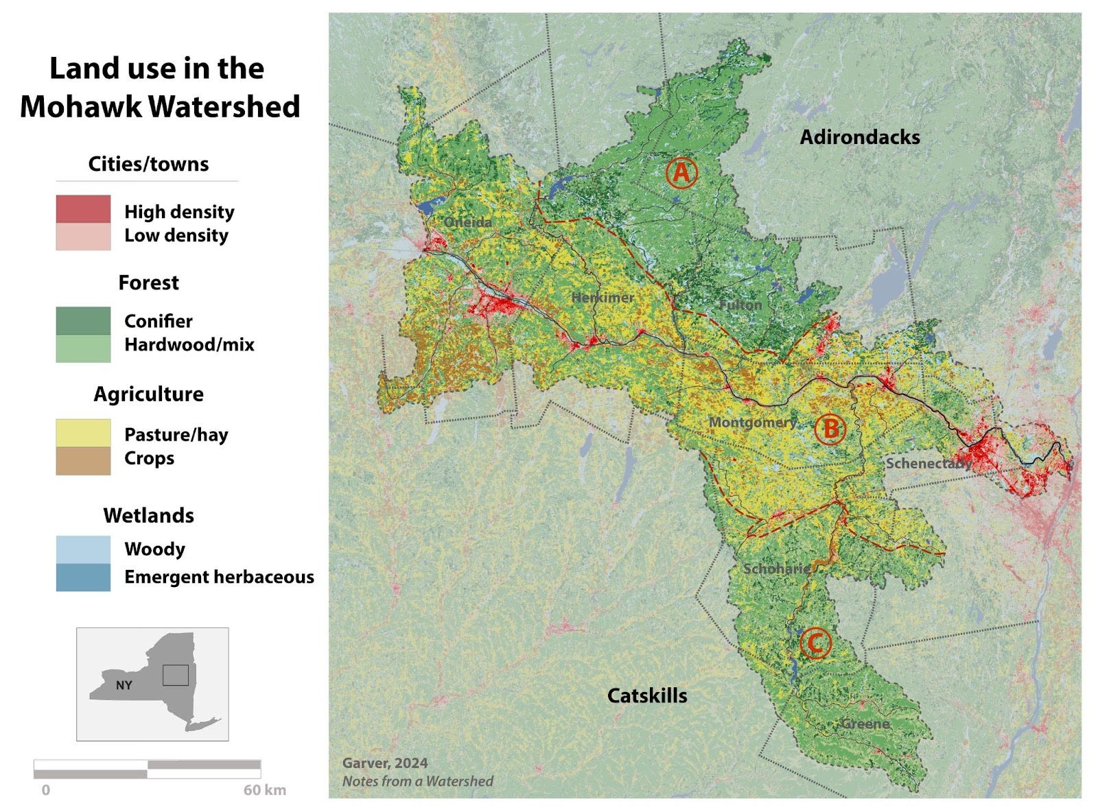
Map of current land use in the Mohawk Watershed, here adapted from the National Land Cover Database (NLCD) at the MRLC [5]. Land use categories are simplified here, but pastures and croplands in the Mohawk Valley are clear and distinctly different from conifer and hardwood forests that dominate the Adirondacks and the Catskill Mountains. The general boundary of the three primary ecozones are labeled: A - Adirondacks, B - Mohawk Valley, and C - Catskills.
Large-scale deforestation followed the arrival of European settlers, and by the 1880s, forests covered only about 20% of New York State. Today, that figure has increased to approximately 62%, or around 18.7 million acres, which serves as a significant carbon sink that is integrated into the State climate plan [3,6]. This forest regrowth is a result of afforestation, reforestation, and natural regeneration, and there is potential for further forest expansion. The State currently has about 3.9 million acres suitable for afforestation or reforestation, of which 1.6 million acres are classified as marginal cropland and pastureland [3].
The processes of “re-foresting” have distinct and slightly different meanings: afforestation refers to planting trees on non-forested land, reforestation involves restoring forests to areas that were previously forested but disturbed, and natural regeneration is a more passive process, allowing cleared land—primarily abandoned farmland in this context—to regenerate naturally. "Reforestation" is commonly used in a more generic sense to describe the transition from deforested lands, often agricultural, back to forested lands through either planting or natural succession [7].
In the last half century, the Northeast has experienced reforestation due to the transition of agricultural lands to forested lands [8]. Using forest inventory reports, Allyson Clark showed that the Northeast (NY and New England) has seen change across the region, but that regrowth has been especially dramatic in central New York [9]. In her thesis, she shows that between 1950-55 and 2005-10 the largest fractional reforestation in the Northeast has been in central NY, including much of the rural lowland area of the Mohawk Watershed. Some counties in the Watershed have had forested land more than doubled in this interval. Change over this time interval was significantly less in already forest-rich regions of the protected areas of the Adirondacks and the Catskills [9]. A large part of the transformation is driven by the abandonment of marginal or poor performing farmland. An important question is how this change is affecting the Mohawk Watershed, because a central concern of Watershed residents is flood attenuation and sediment accumulation in the main stem of the river.
It is clear that beavers, land use, and reforestation are inextricably linked in a complicated way. Beavers build wetlands; to do this they need space, but they are also targeted by trappers for their valuable fur. They also cause problems for some landowners because lands flooded by beaver wetlands may impinge on the built environment - so-called “nuisance beavers”. In the winter of 2024 I had a conversation with a NYS registered trapper who traps beavers in both the Mohawk lowlands and the southern Adirondacks. He told me that most of his new and expanding nuisance trapping was in the Mohawk lowlands and that beaver populations were relatively stable in the Adirondacks. Hence, anecdotally, it seems as though the current expansion of beaver populations is occurring mainly in the Mohawk Valley in land that is undergoing gradual transition. To evaluate this change we can divide the Mohawk Watershed into three primary ecozones: southern Adirondacks, Mohawk lowlands, and the northern Catskills (see map). Here we will only consider the Mohawk lowlands because that appears to be where the most dramatic change is occurring.
Recent land use change in the Mohawk Lowlands can be evaluated using the National Land Cover Database (NLCD) that is overseen by the Multi-Resolution Land Characteristics (MRLC) Consortium [5]. In this analysis we can select that part of the watershed in the Mohawk valley and exclude the fractions that are part of the Adirondacks and the Catskills, and the lowland region I selected for analysis makes up about 64% of the watershed (“B” in map). Comparing data from 2001 and 2019, we can quantify land use change that has occurred in the Mohawk lowlands in this 18 year time interval. One finding is not surprising: developed land has increased by 18%.
But the details in the more rural areas in the lowlands reflect change related to fallow farmland reverting to either forested land or wetlands. In this 18-yr interval there was a 77% decrease in shrub/grassland, and this change can easily be accommodated by the 8% increase in forest (by far the largest land area covered in these divisions) and a remarkable 34% increase in wetlands. These wetlands include woody wetlands and emergent herbaceous wetlands, and together they increased from ~332 square miles in 2001 to ~444 square miles in 2019. Much of this increase can be attributed to the success of hard-working beavers. They are making a measurable difference in land use, and it is in our best interest to understand the effect that this difference has on flood attenuation and trapping sediment, because we might want to give them a hand in the job they are doing.
Natural forest regeneration has been ongoing in the Mohawk lowlands, but if we look farther back in time, a significant increase occurred in the late 1980s and the early 1990s. The US Department of Agriculture (USDA) conducts a comprehensive agricultural census every five years that provides insight into change that has occurred in the US, but here we focus on the change in New York [10]. While various farm and agricultural attributes are available, milk-cow numbers and farm acreage provide the most insight into change that has occurred in the Mohawk Watershed. Using data since the 1970s, we can see that there has been a significant decline in both land held in farms and the number of milk cows. The USDA data also show that milk production has stayed about the same, which partly reflects increased efficiency. From 1982 to 1992, the number of milk cows dropped by about 18% and there was a reduction of approximately 2 million acres of farmland statewide. This contraction in the dairy industry undoubtedly had an important impact on land use in the Mohawk Watershed, and it is almost certain that this change has favored reforestation and beavers.
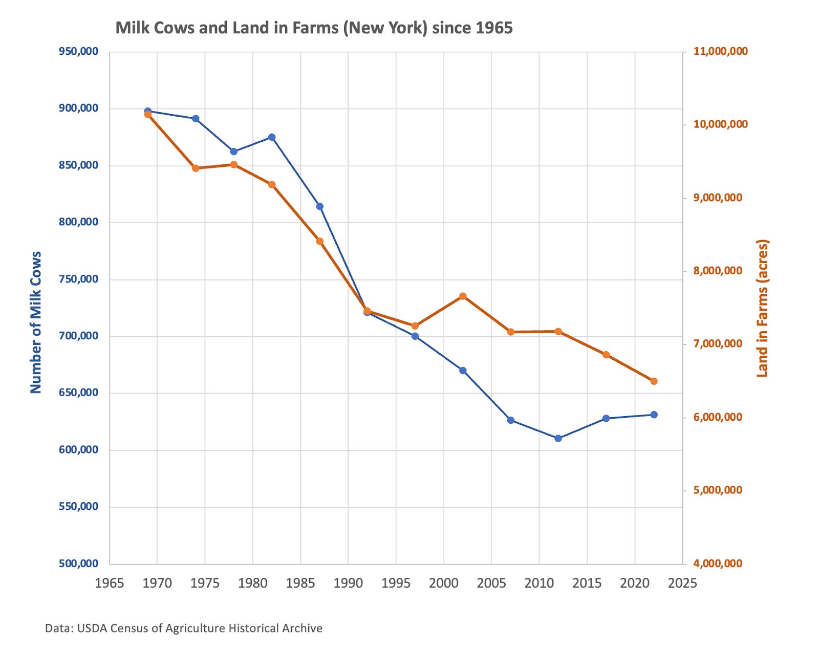
The tipping point for reforestation and the partial abandonment of farmlands in the Mohawk Watershed may have been the 1985 Food Security Act. This act with its various provisions appears to have affected land use in two significant ways. First, it addressed the oversupply of milk through the buyout of dairy farms, leading to the closure of many dairy farms. Second, it addressed long-standing problems of erosion and water quality by encouraging conservation and wetland protection on private land. Frederick Steiner at the University of Colorado described this “The most sweeping federal land use legislation for privately held US farmland since the Homestead Act of 1862…” [11].
Before 1985, government price support for milk led to an oversupply, so the Food Security Act of 1985 included corrections for the long-term price stability of milk products in the US by attempting to align the supply of milk with demand [12,13]. Rather than buying surplus milk to support prices, the government bought dairy farms to reduce the milk supply. The mechanism for this pivot was the Dairy Termination Program (DTP), which offered incentives for dairy farmers to exit the dairy industry altogether [14].
The Dairy Termination Program had important effects on land use in NY State [12]. In the late 1980s, dairy products accounted for nearly 60% of the farm revenue in the State, and thus dairy farms have a major impact on land use. When the DTP was announced, about 19% of all NY dairy farmers (2600 total) submitted bids to the USDA for buyout, and 538 were selected for the program. An analysis of both successful and unsuccessful bids for the buyout program showed that many NY dairy farmers wanted to exit the industry [12]. The survey showed that for successful bidders (accepted into the DTP), ~85% indicated that they were Somewhat Unlikely or Definitely Not going to resume dairy operations after five years (the length of the DTP contract). About 40 of the unsuccessful bidders planned to exit the dairy industry in the following five years, despite not being bought out. Thus, farm acreage and the dairy industry have been declining for nearly a century, but contraction seems to be particularly abrupt following the 1985 Food Security Act, and it is likely that set the stage for the remarkable success of beavers and wetland expansion.
Measuring change in land use and transformation of marginal farm acreage can be done several ways, but by far the most effective is to use satellite-based images or aerial photographs that allow measurement of qualitative and quantitative change over time. The satellite-based Multi-Resolution Land Characteristics (MRLC) analysis extends back to 2001, and there are several ways to evaluate change farther back in time. Google Earth images are satellite based, but prior to about 2000 or 1995 images lack resolution. In some cases air photos are available digitally so land use can be evaluated by images back to the 1940s where some of the earliest comprehensive surveys were conducted.
These image options enable us to track the development of wetlands and beaver dam complexes over time. Analysis of air photos shows that reforestation was particularly active from 1981 to 1995, during which beaver populations appear to have established themselves and expanded their dam complexes, and presumably changed the hydrology of the watershed. The following three examples highlight long-term land use changes and forest regrowth across multiple decades, extending back beyond just the early 1990s transition period.
Case 1: Eva’s Kill watershed (Schenectady/Montgomery Co).
Active farmlands surround the lower Mohawk River, and much of the area in Fulton, Schenectady, and Montgomery counties are relatively flat with low-gradient streams. The Eva’s Kill (and associated tributaries) is a small watershed near Amsterdam NY. This area has accessible air photos (i.e., online), so we can see eighty years of clear change from farmlands to woods with an associated beaver dam complex (multiple dams) that is growing with time. The record here shows that the most dramatic phase of reforestation occurred between 1981 and 1995 (not shown). In this complex, beaver dams first appeared in an air photo from 1981, and by 1995 the wetlands had expanded to ~3.9 acres. Today the complex of wetlands and beaver meadows is 4.2 acres. Reforestation in this area has reclaimed about half of farm fields that were active in the early 1940s.
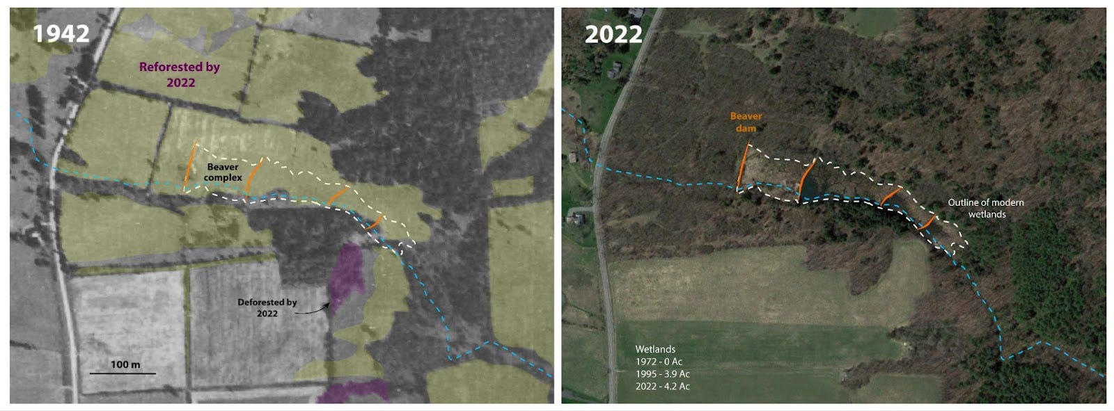
Images showing the modern outline of a beaver dam complex (four dams in orange, and the stream in light blue) determined from 2022 satellite images (right), and then superimposed on an air photo from 1942 (left). The basic structure of the farm fields was intact in 1972, and the onset of reforestation is first apparent in the 1981 image, but by 1995 reforestation was significant. Air photos are available online through the Schenectady County Internet Mapping System (here), used by the county for regional planning. Satellite image from Google Earth.
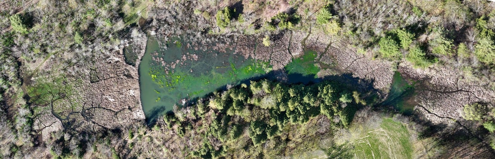
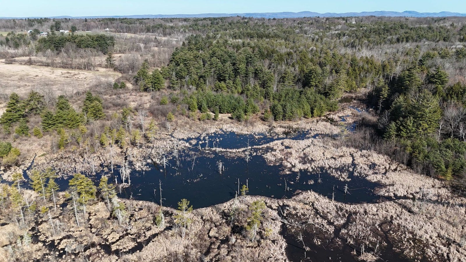
A birds eye view of this thriving beaver-created wetland is shown in the composite photo above. This beaver dam complex has four active dams, and it is surrounded by mixed hardwoods (and some conifers) that provide excellent habitat for the beavers that call this home. These dams and wetlands are on private property, and trapping is prohibited. Photo mosaic was taken in early May of 2024. (Photo: JI Garver, 2024)
McQueen Creek, Kayaderosseras Creek drainage (Fulton County).
Farmlands in Fulton County merge northward into the forested southern slopes of the Adirondacks, and streams here flow south to the Mohawk River. Beavers are doing well re-establishing themselves in fallow farmland that is slowly being reforested. Satellite images show that the dam complex was constructed after 1995, and since then reforestation has been continuous in what was likely less productive farmland adjacent to McQueen Creek.
Beaver dam complex on McQueen Creek, which is part of the Kayaderosseras Creek sub-watershed in the Mohawk basin. The dam in the main part of the beaver dam complex (lower center in photo) is ~280 meters long, which makes it one of the longer beaver dams in this area. The entire wetland and associated beaver meadows currently occupy about 24 acres. This view is to the north toward the Adirondack Mountains in the distance (Photo: JI Garver, 4/2024).
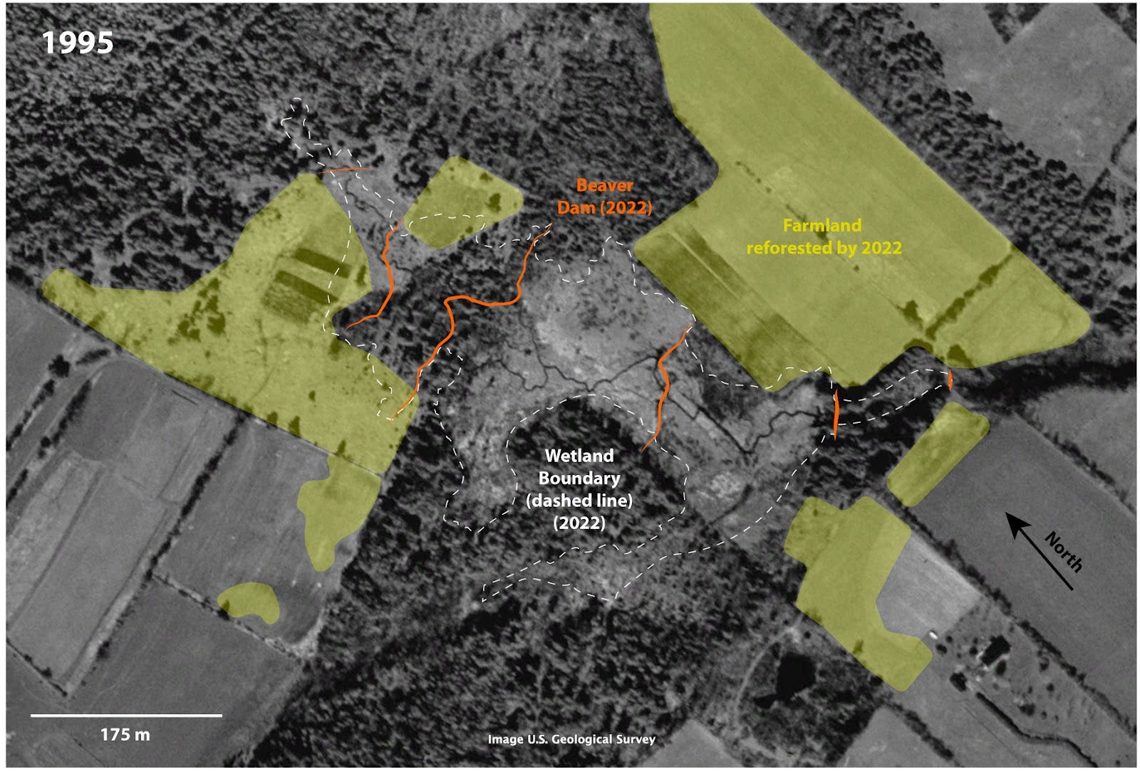
Image of the McQueen Creek area in 1995 with the outline of the recent beaver dams and meadows from today superimposed (in orange/white). Google Earth image from the USGS.
For a record of change in this particular beaver dam complex, we need to go back to 1995 where we can see remnant dams and beaver meadows, but the complex was not active. Fields, including pasture and crops, were adjacent to the stream and marshes. The overlay of the modern footprint of the dam complex shows how the former sites were re-occupied and expanded, and that abandoned fields have reforested. This beaver dam complex on the upper part of McQueen Creek is notable because it breached on 17 July 2020 after several inches of rain.
Chaughtanoonda Creek (Schenectady County). Among the three case studies, reforestation in the headwaters of Chaughtanoonda Creek in Schenectady County is perhaps the most striking. Eighty years ago this area was almost entirely farmland, but it has now transformed into a largely forested landscape. By 1995, beavers established a dam complex here, creating a 1.3-acre wetland, which expanded dramatically from 3.2 acres in 2001 to 12.2 acres by 2014. In 2020, the dam breached, resulting in about 18.2 acres of beaver meadows with remnants of partially maintained dams. Though beavers haven’t fully rebuilt the complex, the extent of wetlands, dams, and canals is still visible in the imagery, and the creek flows downstream through Wolf Hollow into the Mohawk River.
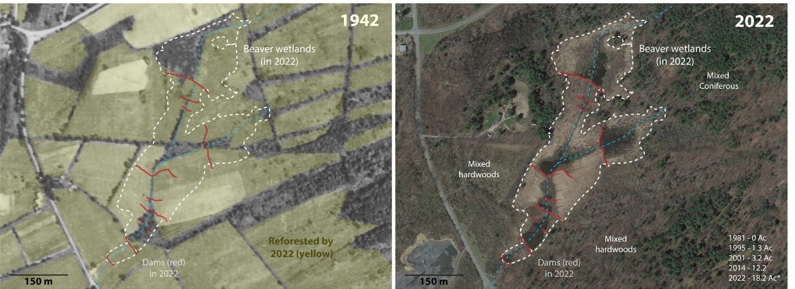
Land use change is particularly striking in and around the beaver dam complex on the headwaters of Chaughtanoonda Creek in Glenville. Beaver dams were first established by 1995 during a period of land use change from a mosaic of farm fields to mixed hardwood and coniferous forests. Here we look at the end-members of that change. The image on the left shows the area in 1942 - almost entirely covered in farm fields - with the modern outline of the beaver meadows (from 2022). In the image to the left, all fields shaded in light yellow are abandoned and reforested by the mid-1990’s (here virtually all land in this image). This beaver dam complex is on private property.
These three case studies are representative of the natural forest regeneration that followed abandonment of marginal farmlands, and this shift was especially dramatic between 1980 and 1990. Coincident with this shift in land use is the establishment of beaver dam complexes and associated wetlands. Using satellite images from these and many other examples in the lower Mohawk, it is clear that wetlands and the size of beaver dam complexes have increased in the last few decades. A key point here is that today the landscape is fundamentally different than it was 30-40 years ago, and the abandonment of farm fields and emergence of mixed hardwoods has been advantageous to beavers because they have suitable habitat and presumably less conflict with land use.
Path Forward. Changes in land use, including farmland abandonment, reforestation, and wetland expansion, are transforming the Mohawk Valley and almost certainly affecting watershed hydrology. Beaver populations are expanding as these changes create favorable conditions for dam-building, which supports flood control, sediment trapping, and biodiversity. Satellite and aerial imagery reveal that since the 1980s, beaver dam complexes and wetland areas have increased, and this ecological shift suggests potential climate adaptation benefits, including carbon sequestration, sediment trapping, and flood attenuation.
In a perspective piece entitled “Beaver: the North American Climate Action plan,” Chris Jordan and Emily Fairfax wonder “Should we entrust a large rodent with such critical environmental engineering tasks?” and essentially conclude that beaver-based restoration should be part of the foundation of a national freshwater climate action plan [2]. Here in New York we may want to partner with beavers in future climate adaptation plans in NY State because when given the opportunity they certainly seem willing to do much of the heavy lifting.
This and other Notes from a Watershed are available at: https://mohawk.substack.com/
Further Reading
[01] Mahoney, M.J., Johnson, L.K., Guinan, A.Z. and Beier, C.M., 2022. Classification and mapping of low-statured shrubland cover types in post-agricultural landscapes of the US Northeast. International Journal of Remote Sensing, 43(19-24), pp.7117-7138.
[02] Jordan, C.E. and Fairfax, E., 2022. Beaver: The North American freshwater climate action plan. Wiley Interdisciplinary Reviews: Water, 9(4), p.e1592.
[03] New York State Climate Action Council. 2022. “New York State Climate Action Council Scoping Plan.” climate.ny.gov/ScopingPlan. Under the NY Climate Act, there was an initial scoping plan (2021 initial scoping plan here) and a Final Scoping plan is here, which was released in 2023. The main chapter referenced above is Land Use (ch. 19).
[04] Auster, R.E., Barr, S.W. and Brazier, R.E., 2022. Beavers and flood alleviation: Human perspectives from downstream communities. Journal of Flood Risk Management, 15(2), p.e12789.
[05] The NLCD (National Land Classification Database) and other land use data are accessible from the Multi-Resolution Land Characteristics (MRLC) consortium, and group of US federal agencies that coordinate land use cover information (here).
[06] Albright, Thomas A., Brett J. Butler, Susan J. Crocker, Jason M. Drobnack, Cassandra M. Kurtz, William H. McWilliams, Randall S. Morin, Mark D. Nelson, Rachel Riemann, Lance A. Vickers, Brian F Walters, James A. Westfall, Christopher W. Woodall. 2020. “New York Forests 2017.” Resource Bulletin NRS-121. Madison, WI: U.S. Department of Agriculture, Forest Service, Northern Research Station. 118 p. https://doi.org/10.2737/NRS-RB-121.
[07] Pfaff, A.S., 2000. From deforestation to reforestation in New England, United States. World forests from deforestation to transition?, pp.67-82.
[08] Swaney, DP., Karin E. Limburg, KE, and Stainbrook, K, 2006. "Some historical changes in the patterns of population and land use in the Hudson River watershed." In American Fisheries Society Symposium, vol. 51, p. 75. American Fisheries Society.
[09] Clark, A., 2013. The impact of reforestation in the Northeast United States on precipitation and surface temperature (Master's thesis, Colorado State University).
[10] Data from USDA Census of Agricultural Historical Archive (here) and 2022 Census of Agriculture (here). Census of Farmland HERE (1997 back). Start HERE (with the main page). Census of farm land from 1964 (to 1930) HERE
[11] Steiner, F. (1989). The Food Security Act of 1985. Land Use Policy, 6(2), 132–140. doi:10.1016/0264-8377(89)90039-2
[12] Simler, KR, Bills, N.L. and Kaiser, H.M., 1988. The impact of the Dairy Termination Program on land use in New York. Cornell Agricultural Economics Staff paper, n. 88-3. (here).
[13] Bausell Jr, C.W., Smith, S.L. and Belsley, D.A., 1992. An analysis of 1980s dairy programs and some policy implications. American Journal of Agricultural Economics, 74(3), pp.605-616.
[14] Weber, WL., Roseberry, JL, Woolf, A., 2002. Influence of the Conservation Reserve Program on landscape structure and potential wildlife habitat. Wildlife Society Bulletin 2002. 30(3), p. 888-898.